
Impressions
From about 50 miles out from the park we could see the dark, flat ridge of the Rocky Mountains on the horizon. The native Blackfeet Indians considered this area the “backbone of the World” – and it is, indeed, the backbone of the continent - the transcontinental divide runs through Glacier National Park.
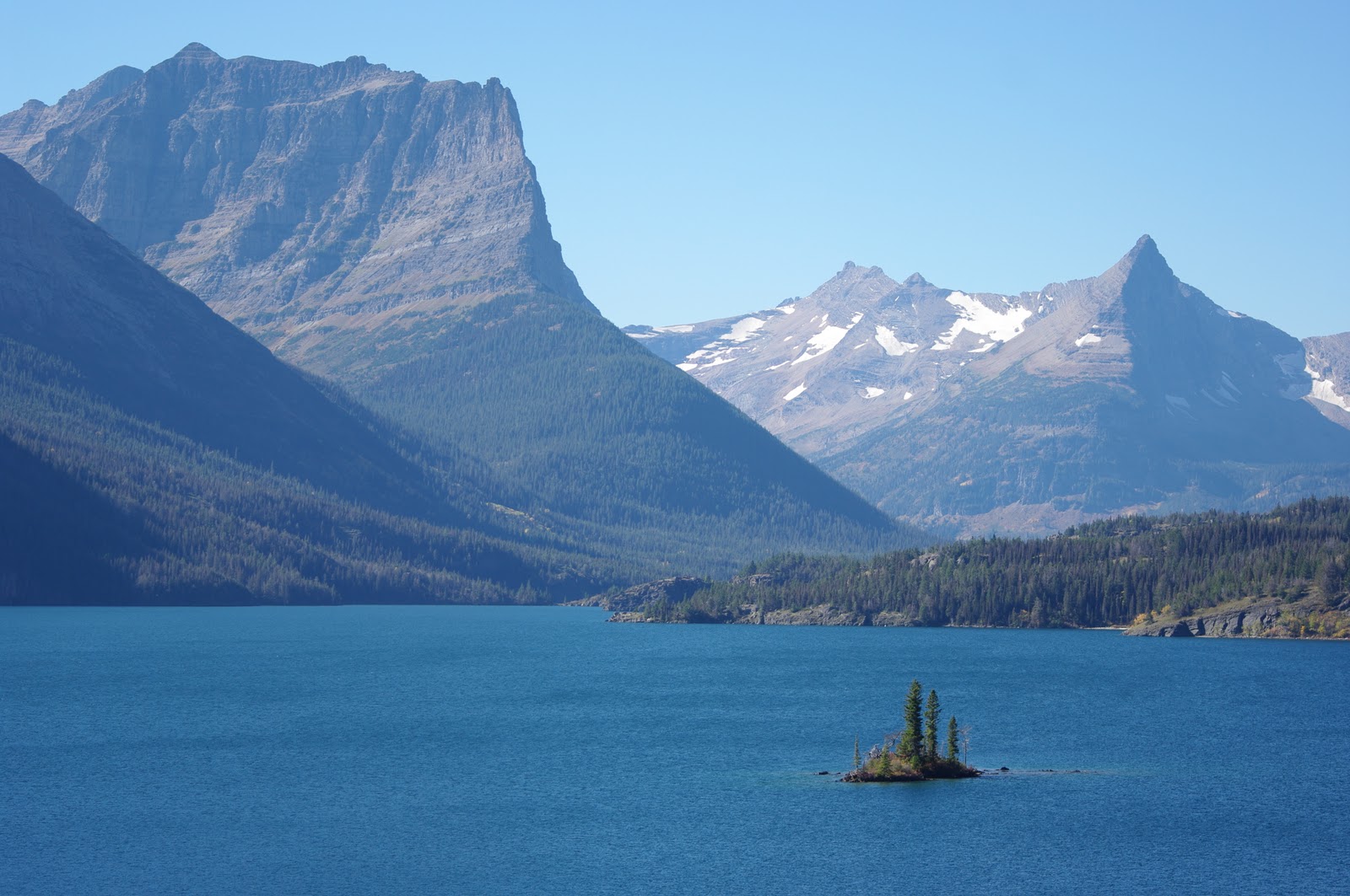
We arrived at Glacier in glory, with fall foliage flanking the roadside like a golden, heavenly choir. A corner turned and majestic, rugged, historic, living peaks were revealed to create a splendid scenery unlike any we had previously encountered on this trip. It is the type of splendor that draws emotion, takes one's breath away literally and brings a swelling of tears to the eye's corner. We were in God's country now. And like God, it is to be feared. Bears, wolves, uncompromising weather, clinically vertical cliffs and uncaring distances. We were terrified, but drawn by the dramatic beauty before us and could not turn away.

History
The Blackfeet people inhabited the region to the east of the continental divide in what is now Glacier National Park and norther Montana. They believe that the mountains are home to spirits and Chief Mountain, in particular, is most important mountain because it is the home of medicine. As is becoming “old hat” to seasoned readers of this blog, French and English trappers were the first Europeans through the area, but it wasn't until the Lewis and Clark expedition in 1806 – which was commissioned by President Jefferson to map the extent of the Louisiana Purchase – that the area entered permanently into the European record in the USA. In fact, Lewis and Clarke missed the lowest pass through the Rockies between Canada and Mexico – the Marias Pass – and it wasn't until 1889 that an explorer for the Great Northern Railway found it and ushered in the modern era of Glacier, and the near destruction of the Blackfeet (primarily due to the decimation of their main food source, the bison).
Glacier was declared a national park in 1910 after a decade of intense lobbying by George Bird Grinnell, who was the editor of the Forest and Stream magazine – and also, incidentally, the founder of the National Audubon Society in 1905. Today the Audubon Society has nearly 550,000 members around the world and is dedicated to restore and conserve natural ecosystems. The society manages 160,000 acres of wildlife habitat in the Americas and publishes the authoritative guides to birds and mammals of Northern America (For more see: www.audubon.org).
Ansel Adams was dispatched in 1941 by the National Park Service to create a photo mural for the Department of the Interior Building in Washington, D.C. that featured the U.S. National Parks. Adams was particularly taken by the dramatic peaks and huge skies of Glacier National Park, and his pictures generated a great deal of interest in the park. Because of the park's propinquity to its existing line, at a time when each of the three great American railways were promoting a National Park, the Great Northern Railway championed Glacier National Park as a tourist destination (Santa Fe chose Grand Canyon and Union Pacific chose Yellowstone). As part of this promotion, the railway hired men from the Blackfeet tribe to travel the country in their full ceremonial regalia, dancing and inviting wealthy easterners to visit Glacier National Park. Members of the tribe were also hired to greet people at the station.

Geology
Now for a little on the geology of the Rockies (by popular demand after the reception to the Algonquin entry). The Rockies are not actually a single mountain range, but rather a collection of many individual mountain ranges that trend generally north-south from northern British Columbia to northern New Mexico. The Canadian Rockies are the largest of these mountain ranges, stretching 1450 kilometers from Liard River through to Helena, Montana (so Glacier National Park forms the southern extent of the Canadian Rockies). This mountain range makes an orderly line of sedimentary strata, formed when the continental shelf of North America collided with the Pacific plate and was pushed up and eastward. Accordingly, these mountains generally have sloping western slopes and sharp, broken eastern faces.

The sedimentary lines of these mountains are clearly evident in Glacier National Park, both as bands of different coloured rock in the cliff-faces of many mountains, and also in the shape of the mountains themselves, through the erosion pattern of their different composite rocks. Softer sediments – shale – erode quicker than harder sediments – carbonates. So where the shelf is pushed up diagonally, the peaks of the mountains are very sharp and the slopes stepped, because the shale is more exposed to erosion and over time causes the hard carbonates above them to collapse. Where the shelf is resting more horizontally, the hard rock protects the softer rock and the peaks are flatter.

Heading further south into southern Montana and Idaho, the Rockies balloon east and west across 500 kilometers with the Salmon River Mountains in Idaho to the Yellowstone Plateau and the Bighorn Mountains in Wyoming. Some of these mountain ranges were formed by the same continental shelf collision as the Canadian Rockies, but others, such as the Yellowstone Plateau and the Absaroka Range were formed by (different) volcanoes. Heading south you get the Tetons, Beartooth, Bighorn, Owl Creek and Wind River ranges that are the oldest in the Rocky Mountains. The tallest mountain ranges in the Rockies are in Colorado, where the Front Range, Park Range and Sawatch Mountains contain the famous 14-ers (peaks over 14,000 ft), which rise from the already mile-high Great Plains. The southern extent of the Rockies are the San Juan Mountains and Sangre de Cristo Mountains, whose snow-melt feeds the Rio Grande.
Finally, it should be noted that the Rocky Mountains form the continental divide of North America, which means that on one side the waters flow to the Pacific and on the other to the Atlantic. There are two places, however, where water flows to three oceans. The great Columbia Icefields in Jasper National Park send water to the Pacific via the Columbia River, to the Arctic Ocean via the Athabasca and Mackenzie rivers, and to the Atlantic Ocean via the Saskatchewan River and Hudson Bay. Triple Divide Peak in Glacier National Park sends waters to the Pacific, Atlantic and Mexican Gulf via the Columbia, Saskatchewan and Missouri rivers, respectively.
Obviously, we could go on at length, because the geology of the Rockies is a fascinating and fertile subject, but to avoid alienating one of our seven loyal followers – if any of you are still reading at this point you'll get another postcard – we'll move on.
The Birds and the Trees
Glacier is famous for Grizzlies. And rightly so – after believed to be close to extinct in the area, a recent survey found far more than they were anticipating. We were advised to carry bear mace at all times, and read copious pamphlets, warning signs and websites explaining what to do in the event of an encounter with the big guy. Unfortunately, these various sources give alarmingly varied advice, although all tend to end with the bear on top and you, well, grizzly. These pamphlets are so grim about your chances of warding off an attack that their universal number one best tip to avoid bears: sing as loud as you can while walking. In addition, Glacier boasts big herds of mountain goats, bighorn sheep, elk and – apparently – our old nemesis, the moose.

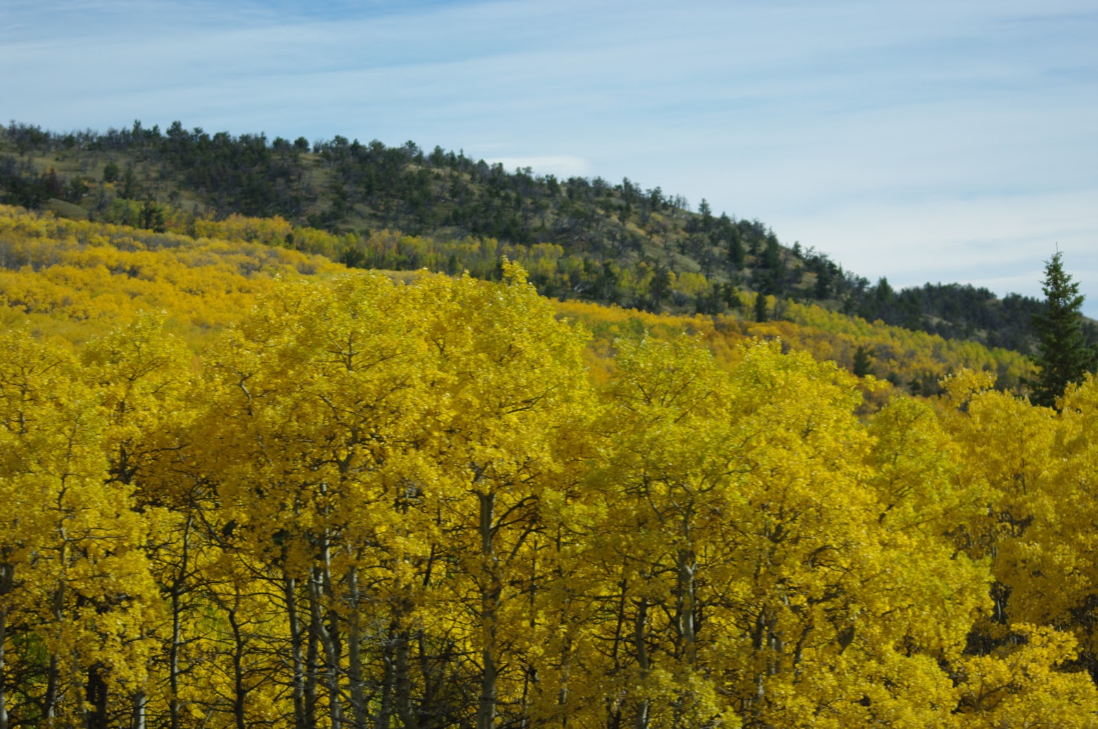
Glacier is also famous for its spring wildflowers and, the rest of the year, for pine varieties – fir, spruce, ponderosa, whitebark – but most notably for our visit, the trembling aspens. There are glades as well as whole mountains full of aspen trees. Aspens favour areas with more sunlight and wetter soils (keen readers will recall from the Algonquin article), but the odd frisky sapling will grow up in the middle of a bad old pine forest, and these guys are even more spectacular in the fall for their efforts. In autumn there are also huckleberries (like blueberries), which are a favourite desert of the Grizzly, and much is made of this association in advertising for huckleberry products from bakery treats to muesli bars and even martinis.

What we did
As anyone who has visited Alex' old office during the fall/autumn will know, he's a pretty keen follower of the fall foliage, and we've been on our fair share of foliage frolics through New England. In fact, during that season he will often, embarrassingly, be caught with a, internet explorer window open to the fall foliage website (www.foliagenetwork.com). So it will come as some surprise to learn that we were not expecting any fall foliage action as far west as Glacier. Imagine then, dear reader, our excitement as we neared the end of our long schlep across the Midwest and were greeted by an absolute cacophony of bright yellow Aspens – each outdoing the last in depth and brilliance – but presenting whole hillsides in unending cloaks of gold. Their yellows are a most unnatural tone, and in the middle of a stand, the sunlight is completely filtered so that even the bare ground seems to glow yellow.
As we neared the St Mary's visitor center an almighty wind started to blow down the valley over St Mary's lake and we were forced into the lodge for lunch. Shortly thereafter, emboldened by the hearty Indian Taco and Rainbow Trout Sandwich, we set up camp at Many Glaciers at the inspired recommendation of new friends and National Parks veterans Coleen and John. (A big thank you to both for their excellent tips and recommendations). Many Glaciers could accommodate 109 tents or RVs, but was in “primitive” condition when we arrived – which means there is no running water, only one long-drop toilet, and half of the campsites are fenced off. Even in primitive condition, the situation of the campsite is inspired. Our site – 101 – was just above Swiftcurrent Creek, which is just below Grinnell Point, which rises sheer for about 200 meters. As we sat down to a cup of tea after setting up the tent a friendly local pointed out a mountain goat perched miraculously on the cliff, standing out white against the warm, autumnal tones of the cliff.

Our first morning was crispy clear and we were treated to a light-show from the comfort of our tent as the first sun on the tops of the mountains painted them a dull bronze and seemed to bring them closer. Filled with the exhilaration of the clear air, muscular mountains, bouncing streams and shimmering foliage, we gulped down our tea and coffee and verily skipped off on the Grinnell Glacier walk – 11 miles return, elevation gain 1600 ft. This is a walk up one side of a valley, gradually ascending the valley wall up onto a hanging valley at the back of which rests the Grinnell Glacier, and above it, the Salamander Glacier.
I imagine it's a beautiful walk at the worst of times, but we were walking through the full riot of fall colours, and there was literally never a dull moment. Probably the least dull moment came near the start of the trail, we were busily chatting and singing away – to warn the bears that we were coming – rounded a bend and nearly walked into a big old chocolate moose cow, right next to the path. At first all we could see was the head, but we mistook that for its side. The moose is massive, but it's head is ridiculous – twice as long as a horse's face with a mouth like a camel and eyelashes that would make a giraffe blush. She munched away at the fall foliage, hopped over the path – she had lovely long, shapely legs – and wandered off into the forest. So the myth is busted, they do exist, and she was worth the wait.

Most of the Grinnell Glacier walk is above the regular tree line so the views up and down the valley are outstanding. The valley floor is graced with a string of small lakes created by the morrains (piles of rocks left behind by glaciers as they commence their retreat back up the valley) of the various glaciers that have marched down the main valley. These lakes are a very pale blue colour (all glacial lakes are this colour) due to the presence of very fine silts (known as glacial flour) suspended in the water. This glacial flour indicates that the glacier which feeds the lakes is still actively grinding up the rocks beneath it and in so doing, widening and deepening the valley. It's great when there is a clearly defined objective at the end of a walk, and with this walk, it's the glacier. You end up at a lake in which the glacier is partly submerged. The rock surrounding the lake looks raw, and you can easily imagine the grinding forces of the glacier gouging them out. There is almost no vegetation and the only sound is the wind in the peaks above and the crystalline trickle of that cold, hard meltwater as it runs over the newly-exposed rocks.

Day two was a rest day, which we spent in a small town called Babb, which is in the Blackfeet Reservation and boasts about 6 buildings, 2 of them churches, 2 of them pubs, a general store and a cafe called Fire Horse Cafe. Fire Horse Cafe makes an awesome breakfast burrito – see food section below for deets. We also fitted in a short hike to Apikuni Falls and much vain searching of the mountain sides for bears.

Day three we did the Ptarmigan Tunnel walk (10.4 miles return, elevation gain 2300 ft), which is through a valley of pines and aspens, gradually ascending towards the Ptarmigan Wall, which is a broad, sheer cliff face joining some magnificent peaks. At one end of the wall is Iceberg Lake and at the other Ptarmigan Lake and above it, the tunnel. This is another great example of a wonderful objective at the end of the walk. From the lake to the tunnel, the trail goes up a sharp, steep slope of scree through a series of switchbacks that you can see from the lake. The entrance to the tunnel, which is about 15 meters from the top of the Ptarmigan Wall, looks like the door to the mines of Moria, and so we both wished we had Gimly with us. Fortunately it's actually a short tunnel through to the next valley, which is graced by Lake Elizabeth. Immediately through the tunnel, the trail creeps along the edge of a cliff made of a shale that has a rich burgundy colour, which we learned later is called Grinnell Shale.

Day four was another rest day, this time featuring a drive up the famous Going to the Sun road. This road will forever be remembered for us in the song “Going to the Sun” by local artist David Walburn, which tells the story of how the road was built between 1921 and 1932 to join St Mary's Lake in the east with Lake MacDonald in the west via Logan Pass. (You can check this song out at: http://music.myspace.com/index.cfm?fuseaction=music.artistalbum&albumid=montana-life-under-the-big-sky-16732831&artistid=45228473 ).
It is a spectacular drive along St Mary's Lake which is flanked on both sides by those massive cliffed mountains and craggy peaks for which Glacier is renowned. The road was closed for construction after Logan Pass on the west side, so we didn't get to drive right through, but as you can imagine in one of the snowiest parts of the Rockies, the road building window is pretty brief and we were glad to see some Reinvestment and Recovery Act dollars being used on such a worthy bit of blacktop. Another drawback of the impending winter season was that the visitor center cafe was closed, and we were forced back down from Logan Pass before we could do the scenic trail to Hidden Lake by hunger and a burning desire for another Fire Horse Cafe breakfast burrito (available all times of day).

Day five was the big kahoona. In a momentary lapse of judgment, that she was to rue time and time again throughout the long weary hours of day five, Lish allowed Alex to pick the final hike, and he chose Swiftcurrent Lookout (15.8 mile return, elevation gain of 3500 ft). As the name would suggest, this is a walk to the top of the mountain at the end of Switcurrent valley, a no-fuss, direct trail up the valley to the rock wall, and then an endless array of zig-zags across pretty much sheer cliffs onto a saddle, and then another array of zig-zags to the lookout atop the peak. We knew it would be tough, and one of us couldn't believe his luck at being able (by successfully tricking his wife into the belief that it wouldn't be that hard) to do this trail, so we got an early start (for us) and at 8.30 we were singing our way up the valley. At the head of the valley, proud that we'd knocked off almost half the miles in two hours, we came across an ol' mountain man who was finishing off a 5-day loop that included many river crossings and an international boundary. He described the view from the top as “360 Degree Mountains” and the trail down as “very picturesque.” That's when we started the long trek up the zig-zags which lasted about three hours. We did a lot of singing, sweating and soul-searching in that time, but were rewarded with the ultimate prize – 360 degree mountains as far as the eye could see. Our trail guide boasts that the vista includes nine lakes, 48 peaks and four glaciers but really, at that stage of the hike it's better described as 360 degree mountains. The vista included mountains, glaciers, glacial lakes, waterfalls, streams, rivers, ridges, valleys, pines, scars of forest fires, a small lodge built out of granite, thin trails marked through parts of the mountains. We spent an hour recuperating and drinking tea and coffee at the top, along with a serve of Campfire Carbonara – see below for recipe – and listening to the tales of fellow climbers who had abandoned their camp on the saddle the previous night when it was invaded by six hungry grizzlies.


Predictably enough, as these things go, our descent featured the best animal spotting of our entire trip. Near the summit we saw a mountain cottontail (aka rabbit) and at the start of the valley we spotted a bull moose across the lake. We then happened across another bull moose in the midst of his bizzaro mating routine. He starts out by pacing his territory and letting off this deep, nasal call every few seconds that sounds like he's trying to suck down a booger the size of his brain – the Mizzy Lake Trail guide from Algonquin describes it as “gawunk.” Then he digs a rutting pit with his big antlers and pees in it. Then he wallows in the pit and starts pacing again, all the time gawunking his big ol' heart out. Eventually, if he's in good form, a cow will be unable to resist his smooth-talking and heady perfume, and will follow his trail of urine down to his pit. I guess we arrived on the scene pretty close to the end, because the bull was literally drooling and gawunking about every second. He crossed the path ahead of us and then set about smashing up the trees near the river to make ready his boudoir. We could hear her up off the trail a short time later and soon enough she too crossed the trail and followed him down to the river, which is when we took our cue and headed home.


With about 30 minutes of light left we spotted a beaver couple building their dam just above Redrock Falls. Goodness gracious! The beaver is a rodent, and looks like a rat the size of a dog. In fact, it is a very highly adapted animal with some very strange features such as two layers of fur, eye-lids which are actually lenses for aquatic sight, lips that close inside their two front teeth so they can chew underwater without drinking and ears that can close underwater. We finally tripped into camp at 8pm for a hearty meal before a roaring fire. Who could ask for anything more?

Food
We mentioned the excellent breakfast burrito above. It was nothing new or fancy, but hot damn, it was good! Potato hash, sausage or ham, egg, salsa, hot sauce, sprinkle of cheddar.
Indian Taco – This is a bread dough shaped into a thick pancake and fried, topped with bison chilli and shredded salad.
Bison Burgers – same as a regular burger but with Bison. Low fat meat, little gamey tasting. They get a mixed reception from us, but because of the novelty, you have to try one if you get the chance.
Campfire Carbonara – this is a recipe stolen from my brother James. It's a simple carbonara – onions, bacon, eggs and herbs – but because the eggs are only partially cooked in the sauce, they are still in fluid form when the sauce joins the spaghetti and so each strand is coated with the flavour-giving sauce before it hardens. Undoubtedly our views are tempered by circumstance, but at the top of that mountain, even cold and a day old, this was the best damn carbonara we ever ate – and we've both been to Babbo twice!

Conclusion
Get out to Glacier, my friends! The remaining glaciers are expected to finish melting and cease to be in the next 20 years, so the earlier the better.
I'm still reading guys! Great post - it looks out of this world and seems like you scored a great time of year to see it (no crowds and fall foliage!). Keep up the great blogging. And come back to NYC!
ReplyDeleteYes - as prophesised, it is our fave park so far. Currently in advanced planning stage of Alaska trip. Just a little hurdle in the form of a border crossing then we're into the wild.
ReplyDelete